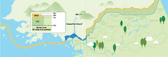
Composition of the DMZ on the Korean peninsula
The DMZ district includes the Demilitarized Zone according to the Armistice Agreement, the Civilian Control Line according to the Military Base and Military Facility Protection Act, and the border area according to the Special Act on Support for Border Area. It is 103km long (41.5% of the total 248km. Gangwon-do accounts for 145km) and 153km² wide (33.8% of 453km² in the south. Gangwon-do accounts for 300km²).
DMZ (Demilitarized Zone)
The DMZ (Demilitarized Zone) refers to a specific area that belongs to a country’s territory but the government cannot station troops and military facilities according to international laws. The DMZ on the Korean peninsula was established when the Korean War, which took place on June 25, 1950, was suspended as a result of the Armistice Agreement on July 27, 1953. In other words, the DMZ was created when the Korean War was not stopped but suspended, and North and South Korea agreed to withdraw each army by 2km to the north and south, respectively, with the MDL (Military Demarcation Line) as the center. It is 248km long indicated by 1,292 signs from Jeongdong-ri (Paju-si, Gyeonggi-do) at the mouth of Imjingang River, to Myeongho-ri,(Goseong-gun, Gangwon-do) in the east sea.
The DMZ, one of institutions under international laws, consists of four elements: demilitarization, existence of a fixed buffer zone, separation of military power or isolated placement, and establishment of an observation agency. Ironically, the DMZ and the surrounding area on the Korean peninsula are the most heavily armed in the world with North and South Korea sharply confronting each other.
Civilian Control Line
The CCL (Civilian Control Line) refers to the border line established at for approximately 10km outside of the MDL (Military Demarcation Line). The 10km-long area called the Civilian Control Zone between the CCL and the MDL is a restricted area for civilians. Originally it was set as a boundary line to prevent civilians’ agricultural activities. However, because national armed forces changed its mission to defense of the ceasefire line, those who are authorized can access and reside in the area to farm. But access by civilians in general is still controlled by the military checkpoint. The distinct line has not been set up yet.
Border Area
The Border Area refers to the contact area and the nearby area that have suffered disadvantages for regional development and private properties for national security since the division of the Korean peninsula. Established by the Special Act on Support for Border Area, it includes cities, counties, and the group settlement area within the DMZ decided by the distance from the CCL and geological conditions, among cities and counties adjacent to the DMZ or the NLL and the area south of the CCL. For administrative purposes, it consists of 15 cities and counties: Ganghwa-gun, Ongjin-gun (Incheon Metropolitan City), Goyang-si, Gimpo-si, Dongducheon-si, Yangjoo-si, Paju-si, Pocheon-si, 6 Yeoncheon-gun (Gyeonggi-do), and Chuncheon-si, Goseong-gun, Yanggugun, Inje-gun, Cheorwon-gun, Hwacheon-gun (Gangwon-do).
Hangang River Estuary
In addition to the overland DMZ, the area from the mouth of Imjingang River to Maldo (Ganghwado) is Hangang River Estuary Neutral Zone. It is designated as the special area for common use by North and South Korea.
NLL (Northern Limit Line)
On August 30, 1953, United Nations Command designated the NLL, a military boundary line, on the East Sea and the West Sea, to limit patrol activities of the Navy and the Air Force of South Korea. It is a de facto sea border: on the East Sea the Military Demarcation Line on the ground was extended; on the West Sea the middle line was designated between North Korea and five islands on the West Sea (Udo, Yeonpyeongd, Socheongdo, Daecheongdo, Baengnyeongdo).